User login
Language
Anonymous's groups in this site
User is not a member of any group.
Your groups across all your sites
User is not a member of any group.
Recent Content
Who's online
There are currently 0 users online.
You are here
by Mizuho Aoki - The Japan Times - October 1, 2011
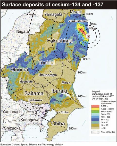
The science ministry's latest aerial monitoring over Chiba and Saitama prefectures in September confirmed that radioactive cesium released from the Fukushima No. 1 power plant has contaminated parts of the Kanto region.
A ministry report released Thursday revealed that contamination was found in northern Chiba, including the cities of Kashiwa, Matsudo and Abiko, and in the mountainous areas of Chichibu in Saitama Prefecture's west and Misato in the prefecture's east.
The highest contaminated areas contained between 60,000 to 100,000 becquerels of cesium-134 and -137 per square meter, it showed. Cesium-134 has a half-life of two years and the one for -137 is 30 years.
Radiation levels in the area were between 0.2 to 0.5 microsieverts per hour, the report said.
Simply calculated, if a person is exposed to 0.5 microsieverts per hour for 365 days, the total dose would be 4.38 millisieverts. Exposure to a cumulative radiation dose of 100 millisieverts increases one's cancer risk by 0.5 percent, scientists say.
Kyodo News reported that radioactive materials spewed from the plant are estimated to have spread in a northwest direction to the mountain areas near the city of Fukushima before winds shifted southwest, sending the materials into the western part of Gunma Prefecture.
Radioactive materials detected in Ibaraki Prefecture are believed to have also been carried by the wind into the northern part of the prefecture before some were blown into the Pacific Ocean, Kyodo reported. However, it is estimated that the wind carrying radioactive isotopes again changed direction, this time contaminating northwestern parts of Chiba Prefecture.
The aerial monitoring was conducted in the two prefectures between Sept. 8 and 12 as part of the science ministry's effort to draft a contamination map of 22 prefectures, from Aomori Prefecture in the north to Aichi Prefecture in the west. In cooperation with local governments, the ministry had completed maps of eight prefectures in the Tohoku and Kanto regions as of Thursday.
The ministry plans to release results of aerial monitoring it has conducted over Tokyo and Kanagawa by the end of October.
http://search.japantimes.co.jp/mail/nn20111001a1.html#.TobIZ2oWusk.twitter


Recent Comments