You are here
Residents near Fukushima nuclear plant make own radiation map, clean contaminated areas
Primary tabs
"We can't keep on relying only on the government," Kisao Watanabe, 70, the chairman of the council, said. "We decided to do what we could by ourselves, hoping we can return to normal life as soon as possible."
Source: The Mainichi Daily News September 27, 2011
English Translation | Original Article Japanese
MINAMISOMA, Fukushima -- Residents in this city, some areas of which fall within the 20-kilometer no-entry zone from the crippled Fukushima No. 1 nuclear plant, have organized a council to measure radiation levels and remove radioactive material spread from the power plant.

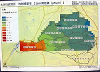
The council has also published a radiation map that is twice as precise as the one released by the government, making it the most up-to-date and detailed radiation map available for the area.
In the beginning of July, residents from the Ota region in the Haramachi Ward in the city of Minamisoma, gathered to organize the 'Ota area reconstruction council,' the activities of which involve measuring radiation levels within the area and decontaminating public roads.
"We can't keep on relying only on the government," Kisao Watanabe, 70, the chairman of the council, said. "We decided to do what we could by ourselves, hoping we can return to normal life as soon as possible."
After inviting nuclear experts to teach them how to use radiation measuring devices -- which they purchased with a 500,000-yen subsidy from the local government -- the members spent two weeks from July 13 through July 30, dividing themselves into groups of two to three, to inspect various locations within the region. With the help of a GPS (global positioning system) and four measuring instruments, they inspected radiation levels at a total of 470 locations within the Ota district.
Based on the results of their findings, the council completed a map on Sept. 2, which displays radiation levels within the district, given for one centimeter and one meter aboveground for all 470 locations, one location for every 200 meters.
The map is the most up-to-date and detailed one currently available, as the one issued by the government -- also in September -- shows radiation levels in the areas around the Fukushima No. 1 Nuclear Power Plant at one location for every 500 meters.
On Sept. 15 council members distributed the map to all 1,000 households in the area.
According to the council's map, radiation levels in all inspected locations were measured at 0.25 to 4.62 microsieverts, but with the exception of mountains and forests in the western part of the prefecture, radiation was comparatively low.
Meanwhile, on Aug. 28, 90 council members decontaminated approximately 800 meters of sidewalks along the ward's main public roads in another initiative to speed up the city's recovery.
"It is very sad indeed," Watanabe said, referring to the fact that after the Fukushima disaster many schools in the city have closed and a number of families with small children have left. "All we want is to return to a normal life. We understood well that the government never had a disaster-preservation plan, despite building 54 nuclear power plants across the country," he added, vowing to continue the council's initiatives.


Recent Comments