Mapping - Japan

Primary tabs

The Mapping Working Group is focused on enabling situational awareness improving health and human security in Japan.

The mission of the Mapping Working Group is to enable situational awareness improving health and human security in Japan, with a focus on the Health Capacity Zones most impacted following the March 11 earthquake/tsunami, and the failures of damaged nuclear reactors emitting radiation from the Fukushima power plant. 

Working Group email address:  ***@***.***

Members

AlMac99 James Miller Kathy Gilbeaux mdmcdonald

Email address for group

mapping-japan@m.resiliencesystem.org

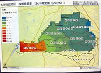
Residents near Fukushima nuclear plant make own radiation map, clean contaminated areas

"We can't keep on relying only on the government," Kisao Watanabe, 70, the chairman of the council, said. "We decided to do what we could by ourselves, hoping we can return to normal life as soon as possible."

Source:  The Mainichi Daily News September 27, 2011
English Translation  |  Original Article Japanese

MINAMISOMA, Fukushima -- Residents in this city, some areas of which fall within the 20-kilometer no-entry zone from the crippled Fukushima No. 1 nuclear plant, have organized a council to measure radiation levels and remove radioactive material spread from the power plant.

FukushimaResidentsMapping

The council has also published a radiation map that is twice as precise as the one released by the government, making it the most up-to-date and detailed radiation map available for the area.

Attachments via Al Mac - Tools

I am using this naming, in hopes of me being able to find this post again, next time I have some important attachment which I think is worth sharing.

Hopefully my doc naming is meaningful to other people:

  • What kind of doc content is this?
  • Vintage of information
  • Organization from which it came
  • Any further clarifications needed?

My maps directory of sources:

Fukushima Isotope Data - by Global Dirt Assessment Team

This data was taken by a Global DIRT assessment team within 2km (1.2 miles) of the Fukushima I Nuclear Power Plant. Data was collected using a Berkeley Nucleonics Corporation SAM 940 Defender / Revealer. The map below represents only readings which contained isotope levels (about 451 of the 1654 current readings). Be sure to check back as this page will be constantly updated.

http://www.globaldirt.org/map/ 

Maps - Crowd-Sourced Realtime Radiation Monitoring

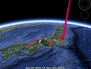
There are now hundreds of radiation-related feeds from Japan on Pachube, monitoring conditions in realtime and underpinning more than half a dozen incredibly valuable applications built by people around the world. They combine 'official' data, 'unofficial' official data, and, most importantly to us, realtime networked geiger counter measurements contributed by concerned citizens.   Now we're even seeing some tracking radiation measurements of tap water.

Google Earth powered by Pachube.com

rdtn.org

Japan Geigermap


Japan Radiation Map

Map in English and in Japanese.  Choose the Prefecture whose map you want to see.  You might start with one whose color code is other than "normal."

Realtime radiation data collected via the System for Prediction of Environment Emergency Dose Information(SPEEDI).

To make sense of this, you need to view some of the posts about the levels of radiation, because there is huge hype.

No one has got radiation sickness yet. 

You could eat the "contaminated" food for a year & get less radiation than one cat scan.

Japan Weather

Japan Weather, Climate, and current crisis links:

  • Weather Forecasts
  • Weather Maps
  • Earthquake info
  • Volcanoes and Volcanic Ash
  • Portal for info about recent disasters

Pages

howdy folks
Page loaded in 0.602 seconds.